
Human motion.
Approach, movement, and direction. Our starting point is measured indoor human Doppler.
Distributed radar · Situational awareness
Understand what moves around you.
Building accessible, networked radar sensing.
Bench platform live · Field validation next
RASD is building distributed radar for general detection and situational awareness. People, vehicles, and airborne objects are application areas we’re exploring—not separate definitions of the company.
01 / DetectSense motion.
Observe physical targets.
02 / ConnectBring local observations
into one picture.
03 / InformTurn observations
into useful awareness.
Approach, movement, and direction. Our starting point is measured indoor human Doppler.
Exploring radar sensing for vehicles moving through sites and access routes. Field validation ahead.
Drones are one potential use of the platform. The animation illustrates this application, not a validated deployment.
Current bench results and development targets. Product visualizations illustrate intended applications, not recorded detections or validated classification.
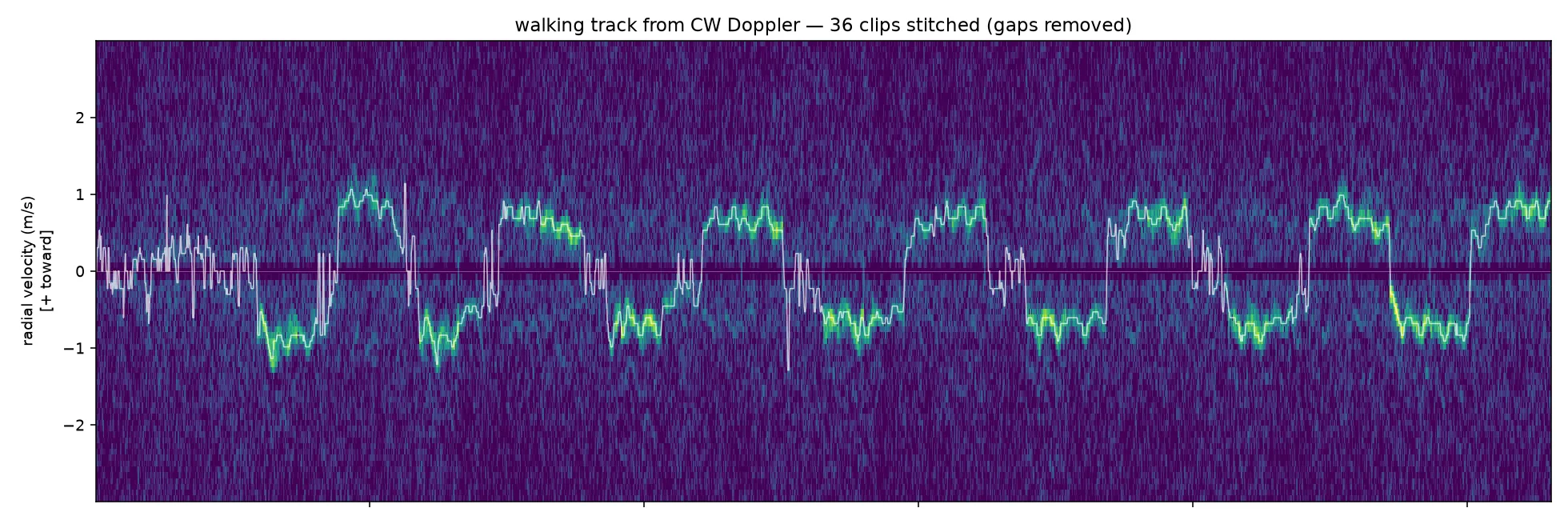
A person walking an approximately 0–5 m indoor path. 36 clips; 54 seconds of active capture. Direction resolved with preliminary I/Q calibration. This demonstrates human motion detection—not drone detection or validated outdoor range.
Physical bench hardware. Repeatable human Doppler. Working CW and FMCW acquisition.
First node: ~150 m. Larger 16-channel array: 300–400 m class. Separate architectures, both modeled under link-budget assumptions — field verification pending.
Field validation, labeled target data, and the first custom radar node.
Radar senses reflections from physical objects. Our focus is turning those observations into a useful picture of movement—not building around one target type.
We’re working toward accessible sensing for site awareness, monitoring, and security. Each environment and application needs its own validation.
Distributed sensing, built toward one view of movement across a site. Placement depends on the environment and the targets being observed.
The target economicsCompact 24 GHz nodes around the perimeter. Placement and coverage will be validated site by site.
Planned track fusion brings observations together. One coherent view is the goal.
Working toward useful tracks, alerts, and integration with other sensors. Outputs shaped by the application.
One application / Illustrative airborne detection
Preliminary targets, not deployed-system pricing. The eight-node example is illustrative: coverage depends on geometry, terrain, clutter, and elevation. Installation, cabling, commissioning, and software subscriptions are excluded. Outdoor performance remains unvalidated.
Three technical cofounders. Hardware, signal processing, and systems development under one roof.
Our long-term bet is better signal processing and better labeled field data: the foundation for detection, tracking, and future target classification across applications.
Contact
Connect with the team about investment, research collaboration, or field testing.
Briefing requests are not open yet. Please check back when our contact channel is available.